
Project Technical Sheet
Project 7
Agar
Vein-hosted gold in the Quévillon–Desmaraisville corridor, on Route 113: two zones, each covered by an NI 43-101 technical report, with historical intercepts such as 0.85 g/t Au over 55.52 m.
- Commodities
- Gold
- Region
- Lebel-sur-Quévillon area, Québec
- Status
- To be provided
- Claims
- 16 (10 + 6) · ≈ 900 ha, acquired in 2025
- Location
- ≈ 60 km north-east of Lebel-sur-Quévillon · Route 113; railway at the south-east corner of Agar
- Technical reports
- Two NI 43-101 reports (64 and 38 pages)
- Historical drilling (7a)
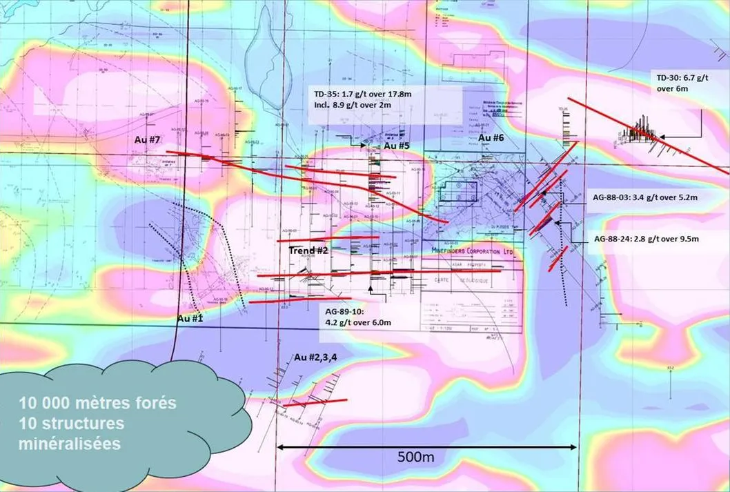
- ≈ 10,000 m (1985–1990) · 10 mineralized structures
- Sub-projects
- 2
Project summary
The Agar project consists of two gold zones, Agar North Zone (7a, Duplessis-Agar property, 10 claims) and Agar South Zone (7b, Duplessis-Mountain property, 6 claims), together about 900 ha, acquired in 2025. They lie about 60 km north-east of Lebel-sur-Quévillon, along Route 113. Each is covered by an NI 43-101 technical report.
Duplessis-Agar is a gold project drilled between 1985 and 1990, in the north-east Quévillon–Desmaraisville corridor, between the Duplessis and Lamarck-Wedding faults. About 10,000 m of historical drilling outlined 10 mineralized structures of quartz–pyrite veins in a gabbro, laterally continuous, in a corridor about 300 m wide (east–west) that remains open at depth and laterally. There has been no recent follow-up. Intercepts include 0.85 g/t Au over 55.52 m and 2.84 g/t Au over 9.50 m.
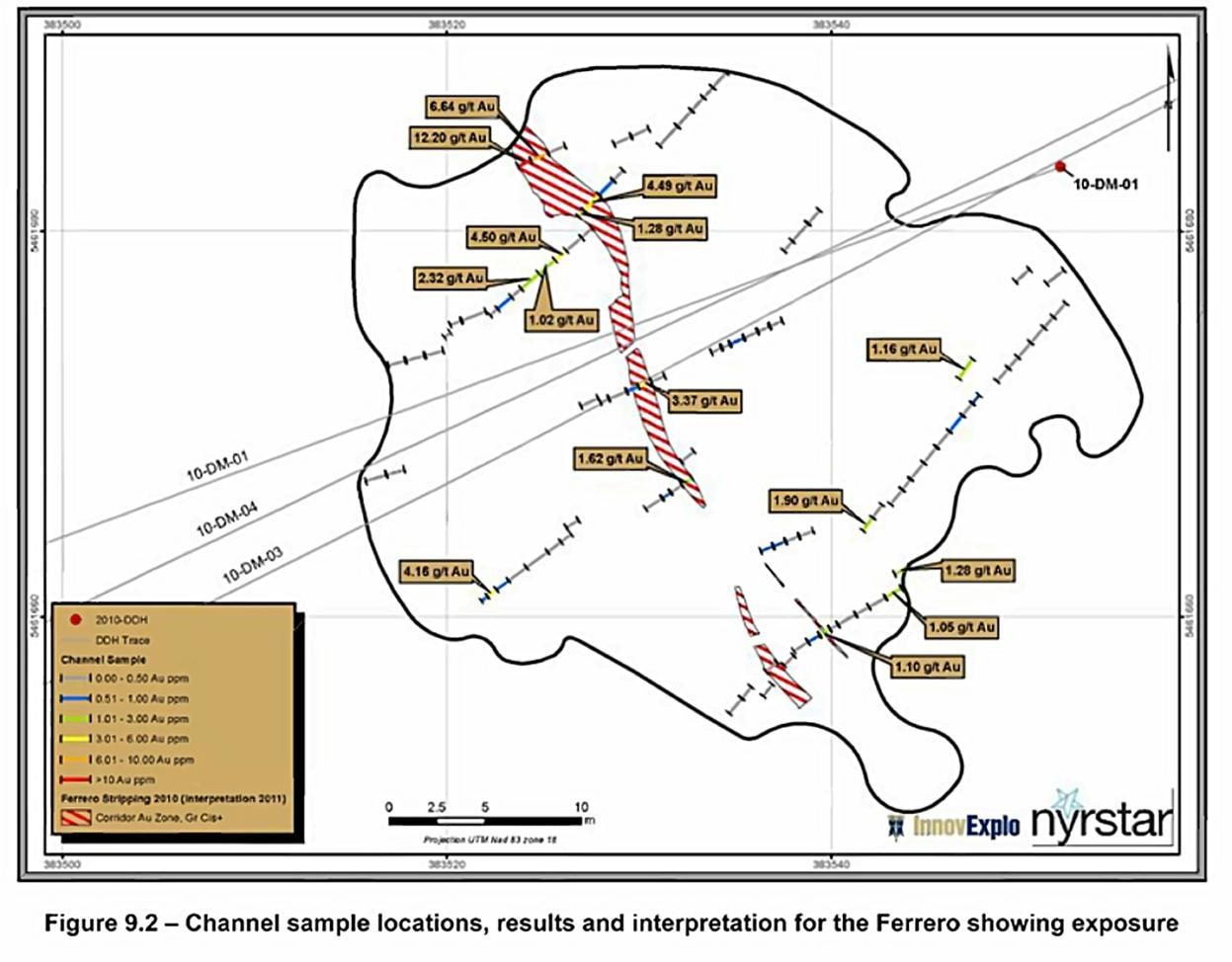
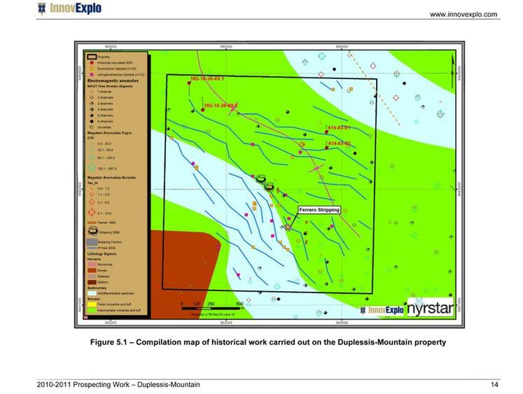
At Duplessis-Mountain, earlier work included a regional EM survey and drill holes (1968–1969 and 1974), then trenching, mapping and sampling in 2002–2005 that found quartz veins and semi-massive sulphides. Work on the Ferrero showing in 2010 (Beep Mat prospecting, 84 channel samples, stripping and 1,346 m of drilling in six holes) returned up to 9.14 g/t Au over 2.0 m in a channel and 4.90 g/t Au over 1.2 m in hole 10-DM-02.
Location
The claim blocks lie between latitudes 49.29° and 49.38° N and longitudes 76.50° and 76.62° W.
2 sub-projects
| Block | Sub-project | Exploration focus |
|---|---|---|
| 7a | Agar – North Zone | Duplessis-Agar property, 10 claims; NI 43-101 report (64 pages); about 10,000 m of historical drilling. |
| 7b | Agar – South Zone | Duplessis-Mountain property, 6 claims; NI 43-101 report (38 pages); Ferrero showing, 2010 channels and drilling. |
Historical exploration results
Results from earlier exploration work, as reported in the sources cited (GM numbers refer to assessment reports in Québec's SIGÉOM database).
| Result | Sample / location | Block | Reference | Date |
|---|---|---|---|---|
| 0.85 g/t Au over 55.52 m | Drill hole TD-30, from 9.15 m (partially sampled) | 7a | – | – |
| 6.69 g/t Au over 6.10 m | Drill hole TD-30, from 47.26 m | 7a | – | – |
| 24.34 g/t Au over 1.52 m | Drill hole TD-30, best intercept of showing 6 | 7a | Beauregard and Gaudreault, 2022 (NI 43-101) | – |
| 12.65 g/t Au over 1.02 m | Drill hole AG-89-02, best intercept of showing 9 | 7a | Beauregard and Gaudreault, 2022 (NI 43-101) | – |
| 11.66 g/t Au over 1.06 m | Drill hole DDH-02, best intercept of showing 2 | 7a | Beauregard and Gaudreault, 2022 (NI 43-101) | – |
| 1.68 g/t Au over 17.80 m | Drill hole TD-35, from 87.38 m (partially sampled; incl. 8.85 g/t Au over 2 m) | 7a | – | – |
| 2.84 g/t Au over 9.50 m | Drill hole AG-88-24, from 121.00 m | 7a | – | – |
| 4.24 g/t Au over 5.99 m | Drill hole AG-89-10, from 159.85 m | 7a | – | – |
| 9.19 g/t Au over 1.64 m | Drill hole AG-89-10, from 163.20 m | 7a | – | – |
| 3.74 g/t Au over 6.62 m | Drill hole AG-89-03, from 186.93 m | 7a | – | – |
| 3.43 g/t Au over 5.20 m | Drill hole AG-88-03, from 40.50 m | 7a | – | – |
| 2.94 g/t Au over 5.91 m | Drill hole AG-89-02, from 89.89 m (partially sampled) | 7a | – | – |
| 1.32 g/t Au over 8.60 m | Drill hole AG-88-13, from 71.00 m (partially sampled) | 7a | – | – |
| 1.83 g/t Au | Grab sample (quartz veins and semi-massive sulphides) | 7b | NI 43-101 report, work history | 2002–2005 |
| 1.9 g/t Au and 1.4 ppm Ag over 2.28 m | Channel samples | 7b | NI 43-101 report, work history | 2002–2005 |
| 2.69 g/t Au | Grab sample, intermediate volcanic rock containing 8% pyrite (Beep Mat prospecting) | 7b | NI 43-101 report, work history | 2009 |
| 9.14 g/t Au over 2.0 m | Channel sample, Ferrero showing | 7b | GM 66649 | 2010 |
| 3.29 g/t Au over 1.6 m | Channel sample, Ferrero showing | 7b | GM 66649 | 2010 |
| 2.25 g/t Au over 1.5 m | Channel sample, Ferrero showing | 7b | GM 66649 | 2010 |
| 4.90 g/t Au over 1.2 m | Drill hole 10-DM-02 | 7b | GM 66649 | 2010 |
| 2.66 g/t Au over 1.1 m | Drill hole 10-DM-06 | 7b | GM 66649 | 2010 |
Some exploration results presented here are historical in nature and have not been verified according to current NI 43-101 standards. Grab samples are selective by nature and are not necessarily representative of the mineralization on the property.
Targets for the next phase
Exploration targets are conceptual in nature and subject to further exploration work. They are not mineral resources.
- Target 01 · Block 7a – Revisit the historical drilling
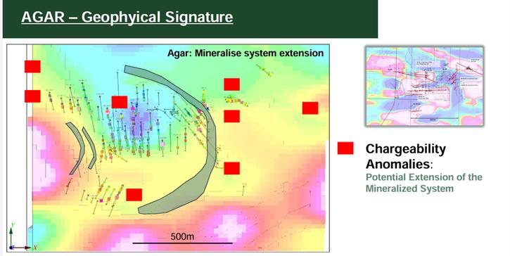
Several historical holes were only partially sampled. Re-sample them and extend the zones identified by induced polarization (IP): the corridor remains open at depth and laterally. - Target 02 · Block 7a – IP chargeability anomalies
Chargeability anomalies interpreted as a potential extension of the mineralized system. Proposed: about 2,000 m of drilling on the IP targets, ahead of a first resource estimate. - Target 03 · Block 7b – Ferrero showing follow-up
The property has seen very limited exploration work; the Ferrero showing remains to be followed up.
Maps and photographs
Technical references
Sources cited on this sheet. GM numbers refer to assessment reports in Québec's SIGÉOM database.
- Beauregard and Gaudreault, 2022 (NI 43-101)
- NI 43-101 report, work history
- GM 66649
- Goldflare Exploration presentation (detail); MRB corporate presentation (projects 7 to 10), 2026
- MRB corporate presentation (projects 7 to 10), 2026
- GM 66649 (p. 28), InnovExplo / Nyrstar; MRB corporate presentation (projects 7 to 10), 2026
- GM 66649, InnovExplo / Nyrstar; MRB corporate presentation (projects 7 to 10), 2026
- MRB ArcGIS map, layer “Contours MRB”